Define the place.
Draw a geofence or an elevation-aware volume. Attach the content and actions that belong there.

Turn location, elevation and real-world context into experiences people can use. Transceiver handles the geospatial engine and content delivery. You build what makes your product yours.
Partner access opens in stages. Let’s explore your use case.
Enter a place. Discover its story.
Illustrative experience · Select a scene to replay
A trail becomes a guide. A venue becomes an experience. A worksite becomes a source of timely information. Connect content to places, then let the right context bring it to life.
Draw a geofence or an elevation-aware volume. Attach the content and actions that belong there.
Combine proximity with schedules, weather and audience conditions to decide what is relevant.
Deliver through your app. Surface a story, start a journey or trigger an action as the conditions match.
Bring your own interface, start from a working app, or explore the platform through Espy. Each path uses the same geospatial foundation.
Build a custom experience on the SDK / API. Keep your product’s identity and workflows while Transceiver handles zones, context and location-aware content.
Talk to us about current SDK / API scope and partner access.
Adapt a working archetype to your brand and use case. Keep the features you need and build from a proven foundation.
Explore white-label optionsOur location-aware discovery app puts the platform to work. Explore the experience and request a demo.
See what’s possible with EspyThe building blocks for location-aware experiences, connected in one platform. Open a capability for the technical detail.
Go beyond the map radius. Target a footprint, an elevation band or a volume in real space.
Circular and polygonal geofences; spherical and volumetric spatiofences; sea-level-relative elevation bands; proximity-only discovery.
Publish variations once. Deliver the version that fits the weather, schedule and audience.
Time of day, date windows and recurring schedules; weather conditions; language, interests and audience rules.
Turn an arrival into a useful next step: a coupon, a voucher, or a digital asset. Or add a custom hook.
Content triggers; background notifications; on-discovery automatic and manual actions; persistent content or content that expires on exit.
Attach useful material to places: stories, media, notices and resources people can open or save. Define your own audiences, identities, and rules.
Rich text and Markdown, images, audio and attachments; externally hosted HTML; isolated content spaces for different brands and audiences. Define default rules, content visibility, and granular permissions.
Let content owners and moderators update the experience in TS Studio, the companion web dashboard, without waiting for an app release.
Browser-based editing: placing veacons, drawing geofences and solid bodies, editing content, setting audience and context conditions, defining categories and schedules, reviewing statistics, managing digital assets, and configuring branding, identity, and permissions.
Understand which places and content engage people through anonymized activity insights.
Context-conditioned discovery, impressions, and interaction statistics; foot-traffic trends by zone and time; content-variant performance; file and API export.
A map footprint is only part of the picture. Transceiver adds altitude, so the story at the summit belongs at the summit.
Designed for outdoor, GNSS-enabled experiences. We’ll help assess positioning requirements for your use case.
Explore your spatial requirements ↗Target an area by its footprint, regardless of elevation.
Define a custom-shaped 3D volume with boundaries in every dimension. Deliver content within the space it encloses.
Build for the moments when location changes what someone needs to know.
A programme at the right gate. A sponsor story at the right moment. A venue that helps visitors find their way.
↗Audio stories along a trail, local knowledge at a viewpoint, and guides that unfold as people explore.
↗Site information and zone briefings that reach teams where they are relevant, across outdoor yards and campuses.
↗From real-world quests to contextual discovery. Build your own interaction on the same spatial engine.
↗Espy is built on Transceiver. Its companion, TS Studio, gives content teams a place to draw zones, publish material and manage what people discover.
Explore the app, its authoring tools and the experiences you can build on the same foundation.
Explore Espy & TS Studio ↗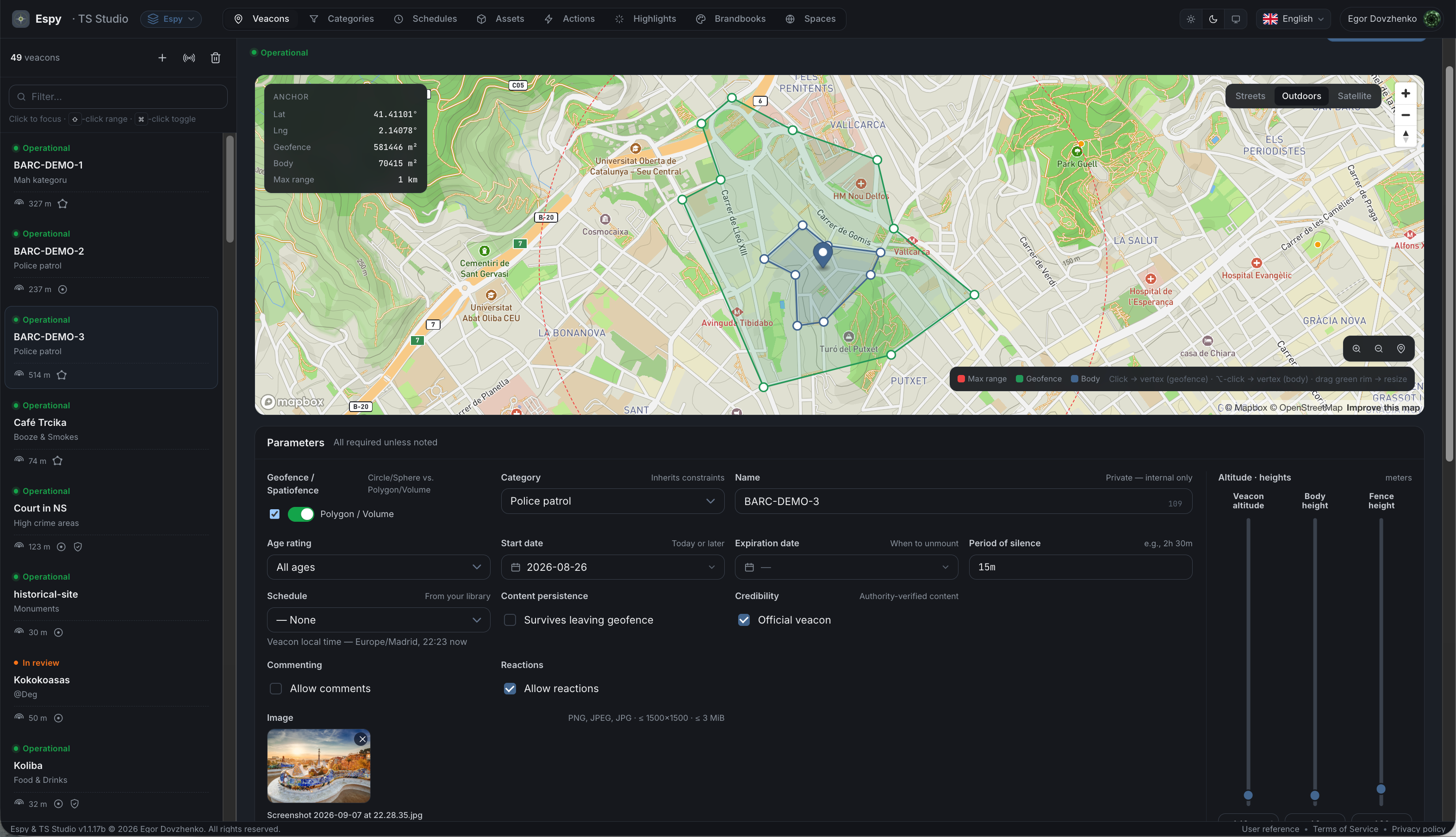
On-device condition evaluation and anonymized engagement insights. No advertising trackers.
Encryption in transit and at rest, with isolated content spaces for brands and audiences.
Discuss EU hosting, data residency and your organisation’s requirements as part of the integration.
The platform already powers Espy. Direct SDK / API access opens to partners in stages. Tell us what you want to build so we can discuss the current scope, requirements and access timeline.
No. Espy is a working example and a white-label starting point. You can also discuss a custom product built on the platform through the SDK / API.
No beacons, gateways or tags need to be installed. The experience uses the location capabilities of connected devices, with spatial zones and content defined in software.
Transceiver is designed for outdoor, GNSS-enabled experiences. Horizontal and vertical accuracy depend on the device and environment. Use elevation bands that allow for positioning uncertainty; exact indoor vertical matching is not a supported assumption. Discuss precision-critical requirements with us before choosing an approach.
Your team can use TS Studio, the browser-based authoring workspace, to manage places, content, audiences and schedules. You keep your own product experience while content teams work on the material behind it.
A white-label app starts from an existing foundation and can be delivered in weeks, depending on scope. Custom integrations depend on your requirements and access to the platform. We’ll work through a realistic path with you.